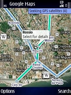
Google Maps (with maps, satellite and aerial images, and street view) is updated. Voice navigation is still missing, but Google has added layers to its maps.
You can overlay maps with Wikipedia entries, traffic information, and public transport lines.
The Wikipedia layer works well, but the public transport lines layer is far from complete. Public transport lines are missing for many cities, including Amsterdam, Barcelona, Rome, Glasgow, Brussels, New York, Wasington DC, Buenos Aires, and Bangkok. Traffic info is only available in a very limited number of locations, so this feature is useless to most people until Google starts providing traffic info for more countries.
You can find public transport info (including route calculations) for hundreds of cities with Métro, but this program doesn't show maps. It would be nice if Métro and Google Maps functionality could be combined somehow. It would be even better if it would work with offline maps, because places where you need public transport info tend to be outside your own country and international mobile data roaming is still horribly expensive.
Speaking of international data roaming...
WARNING: Google Maps automatically connects to the access point you used the previous time, which may be very expensive if you used your 3G network last time and then crossed the border into another country. Google Maps does not offer an easy way to switch off this behaviour. You can change to a cheaper or free connection from the options menu when Google Maps is running, but by then the damage is already done. Google Maps really needs an "ask me first" option before ging online to prevent accidental connections to unwanted access points.
• Google Maps (on the fly installer, only works from your phone's built-in web browser)

No comments:
Post a Comment